- VizAir™ Wind Shear Detection and Alerting System
The VizAir system integrates data from the RWP, MPR, Sodar, and surface sensor provides the ability to constantly monitor low-level wind field characteristics along with any associated wind shear, low-level jets, headwinds, tailwinds, and crosswinds. These parameters are critical to pilot weather situational awareness and gauging aircraft performance. Wind retrievals are processed through wind shear algorithms that derive shear magnitude and depth characteristics. Decision makers (like air traffic control and pilots) use these alerts to make informed decisions about takeoff and landing operations when wind shear conditions exist.
The VizAir system integrates data from the wind profiler, radiometer, Sodar, and surface sensor and provides the ability to constantly monitor low-level wind field characteristics along with any associated wind shear, low-level jets, headwinds, tailwinds, and crosswinds. These parameters are critical to pilot weather situational awareness and gauging aircraft performance. Wind retrievals are processed through wind shear algorithms that derive shear magnitude and depth characteristics. Decision makers (like air traffic control and pilots) use these alerts to make informed decisions about takeoff and landing operations when wind shear conditions exist.
- Hydromet Decision Support System (HDSS)
HDSS provides professional tools and displays designed to aid users in real-time decision-making regarding weather monitoring, nowcasting, flash flooding, water resource management, heavy rain events, and landslides.
HDSS is a turn-key hardware and software system that includes customized web-based displays that integrate hydromet information including weather radar data, rain gauge networks, basin shapefiles and critical flood thresholds, with precipitation estimation, run-off analytics and nowcasting applications to help forecasters and emergency management personnel make informed warning decisions. Radiometrics partners with other companies to provide hydrological modeling capabilities when needed. HDSS is a cornerstone component to Early Warning System implementations.
- Mesoscale Analysis and Prediction Support System (MAPSS)
The Mesoscale Analysis and Prediction Support System (MAPSS) is a complete operational mesoscale NWP system built upon the state-of-the-science Weather Research and Forecast (WRF) model. MAPSS includes a Graphical User Interface that allows the user to setup WRF domains and monitor runs. WRF output can be provided to existing forecaster displays and a custom GIS web-based WRF viewer can be provided. MAPSS can be installed on local hardware or run in the Amazon Web Services cloud.
- Lightning Decision Support System (LDSS)
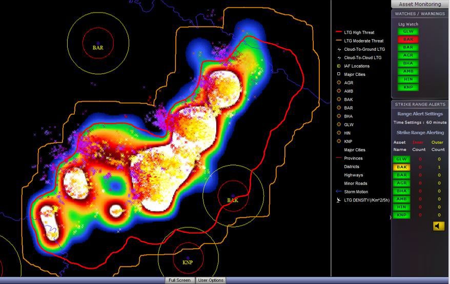
LDSS integrates lightning detection data from existing networks, integrates these data with an asset database, and provides LDSS integrates data from existing lightning detection networks, integrates these data with an asset database, and provides a GIS web based custom display with automated asset proximity alerts. An administration page is provided that allows the user to customize the asset database and proximity alert range rings. LDSS can be deployed using local hardware or the Amazon Web Services cloud.
- Launch Weather Decision Support System (LWDSS)
LWDSS is an atmospheric profiling instrumentation, integration, decision support, and visualization system that provides real-time continuous observations and nowcasting tools to support spaceports and ranges. LWDSS components include:
- Meteorological instrumentation for continuous measurements of atmospheric conditions at the surface and aloft
- Real-time monitoring of lightning activity and triggered lightning potential
- Continuous monitoring of precipitation ranging from thunderstorms to snow using weather radar
- Provision of high-resolution WRF forecasts including wind velocities up to 100 kft Above Ground Level (AGL)
- Detailed forecast planning and meteorological support starting on-site at T-2 days through launch and recovery
- Custom decision support products designed around vehicle and launch criteria
- Meteorological support leading up to and including Day of Launch and recovery.
- Atmospheric Remote Sensing Instrumentation
- Doppler Weather Radars – Need summary descriptive text, and details on sub-page
- Radar Wind Profilers – Need summary descriptive text, and details on sub-page
- Microwave Thermodynamic Profilers – Need summary descriptive text, and details on sub-page
- Acoustic Wind Profilers (Sodars) – Need summary descriptive text, and details on sub-page
- Insert “How Our Remote Sensing Technologies Work” section here (was on Our Brand page)
- Technical Services
- Add WX radar upgrade from magnetron to solid state
- TITAN training and implementation – Reference Roelof
How our remote sensing technologies work
The heart of Radiometrics’ thermodynamic profilers are incredibly sensitive microwave radiometers that passively measure Planck radiation – electromagnetic energy radiated by all substances. These measurements (coupled with ground meteorology and climatological data) are used to produce continuous profiles of atmospheric temperature, relative humidity, vapor, and liquid water, measure soil and snow-pack moisture, and even remotely measure sea surface salinity.
RAPTOR Radar Wind Profilers (RWP) transmit short pulses of electromagnetic energy skyward, and measure the signals reflected from atmospheric turbulence –the same small density discontinuities that cause stars to twinkle. The signal strength, phase, and timing all provide information that our signal processing software uses to determine profiles of wind speed and direction. Depending on the transmitter frequency, power, and antenna size, RWP systems can measure wind profiles to the top of the surface boundary layer or into the stratosphere.
Sodars transmit short audio frequency pulses, and measure the doppler shift of the reflected signals. Digital signal processing software uses the reflected signal strength, timing, and Doppler shift to produce high-resolution wind profiles in the lower boundary layer. Depending on the Sodar model, winds can be measured up to a few km above ground level.